Santa Barbara is a city of distinct neighborhoods, each with its own personality, architecture, and lifestyle. From historic downtown to coastal blufftops, hillside enclaves to beach communities, here is a guide to help you find the area that's right for you.
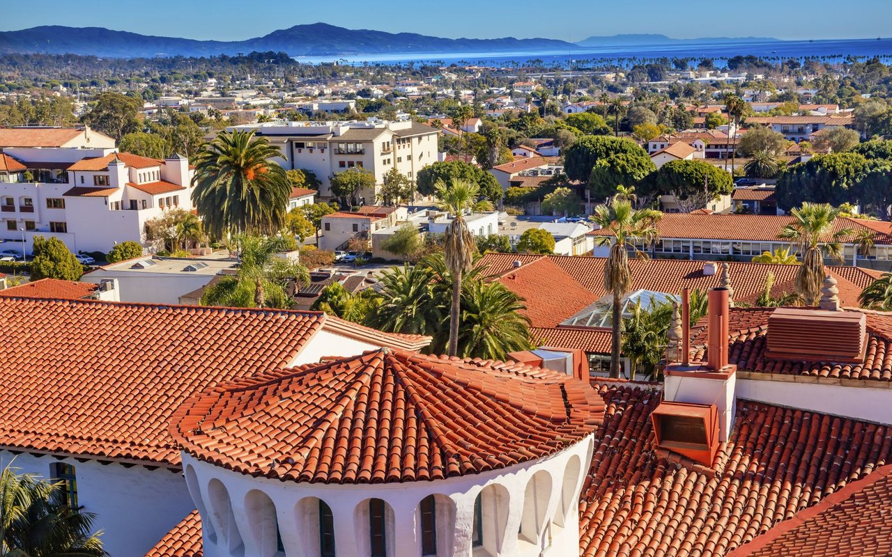
The vibrant heart of Santa Barbara, centered along State Street with Spanish Colonial Revival architecture, boutiques, restaurants, the historic courthouse, Granada Theatre, and weekly farmers markets. Walkable, lively, and full of local character.
View on Map →One of Santa Barbara's most sought-after residential neighborhoods, known for tree-lined streets, gracious Craftsman and Spanish Revival homes, proximity to the Mission, and a quiet village-like feel just minutes from downtown.
View on Map →Perched on the hillside above downtown with sweeping ocean and city views. Homes here range from classic character houses to residences built in the 1950s, 60s, and 70s, all set on terraced streets with a beloved sense of privacy, scenery, and proximity to the Botanic Garden.
View on Map →The lower portion of the Riviera where the hillside meets downtown, with a mix of historic and mid-century homes, walkable streets, and easy access to both the Mission, State Street, and the Eastside. A seamlessly connected address with great views.
View on Map →A great location along Santa Barbara's coastline, adjacent to the Santa Barbara Zoo, Chase Palm Park, and the iconic East Beach volleyball courts. A lively stretch with easy access to the waterfront path, Stearns Wharf, and year-round outdoor recreation.
View on Map →A well-established residential neighborhood in the foothills above upper State Street, known for its tree-shaded streets, good schools nearby, canyon access, and a true neighborhood feel. Popular with a wide range of buyers.
View on Map →The upper reaches of San Roque above Foothill Road, with larger lots, more seclusion, and stunning mountain and city views. A premium address within the already desirable San Roque area.
View on Map →A peaceful, established neighborhood between upper State Street and the foothills, known for its diverse architectural styles, mature trees, and quiet residential character. A hidden gem for buyers seeking tranquility close to everything.
View on Map →A lush, wooded canyon neighborhood above the Old Mission, beloved by nature lovers and hikers. Home to the Natural History Museum and Santa Barbara Botanic Garden, with trails, creeks, and a serene, tucked-away atmosphere. One of Santa Barbara's most unique and cherished addresses.
View on Map →The broader foothill corridor above Santa Barbara, encompassing private roads and estate properties with expansive mountain and ocean views, abundant mature landscaping, and maximum privacy.
View on Map →Santa Barbara's creative arts and dining district, tucked between the waterfront and lower State Street. Warehouses converted into wine tasting rooms, craft breweries, galleries, and restaurants make this one of the city's most dynamic and evolving neighborhoods.
View on Map →Located along the waterfront near the harbor, West Beach features a mix of condos, multi-unit buildings, and residences in what is also the city's hotel zone, with a number of small motels and hotels nearby. A walkable coastal location with easy access to the marina, beach, and downtown.
View on Map →A diverse and well-located neighborhood west of downtown with a mix of housing styles, proximity to Alameda Park, and easy access to both State Street and the beach. A centrally located area appreciated for its convenience and authentic neighborhood feel.
View on Map →A well-established neighborhood east of downtown with a mix of housing types, tree-lined streets, and a strong sense of community. Close to State Street, the beach, and the city's east end amenities. A lively and convenient part of the city.
View on Map →An exclusive, private gated community on Santa Barbara's west side, featuring equestrian trails, a private beach, and large estates set among rolling hills and mature oaks. One of the most prestigious addresses on the American Riviera.
View on Map →A hillside enclave to the east of Hope Ranch, nestled between Hope Ranch and Elings Park, with larger lots and serene surroundings. Offers a quiet, elevated setting with a close-knit atmosphere and easy access to the park and west side amenities.
View on Map →A small coastal enclave situated between Hendry's Beach and Hope Ranch, adjacent to the ocean. Homes here enjoy ocean views and a peaceful, tucked-away setting along the waterfront, making it one of Santa Barbara's most scenic residential pockets.
View on Map →A blufftop neighborhood above the Pacific, the Mesa is one of Santa Barbara's most beloved and geographically distinct areas. Known for ocean breezes, casual coastal living, proximity to Hendry's Beach, and a laid-back community character unlike anywhere else in the city.
View on Map →A sub-area of the Mesa situated closer to Santa Barbara City College, offering a convenient location with the coastal character the Mesa is known for. A popular area for those wanting proximity to both the college and the blufftop lifestyle.
View on Map →Also a sub-area of the Mesa, Marine Terrace II features slightly larger lots than Marine Terrace I and offers the same relaxed coastal atmosphere in a quieter setting, making it a desirable address for those who appreciate the Mesa's distinctive lifestyle.
View on Map →A walkable neighborhood a short distance from downtown, centered around Oak Park — a beloved local gathering spot known for lively BBQs and seasonal festivals. A convenient and accessible part of the city with a relaxed neighborhood atmosphere.
View on Map →A hillside neighborhood with winding streets and elevated settings, where most homes enjoy mountain views, with some properties also capturing ocean views. A residential enclave valued for its seclusion and scenic surroundings.
View on Map →The corridor along upper State Street and its surrounding neighborhoods, featuring a mix of residential and commercial properties, easy freeway access, and proximity to the foothills. A practical and well-located part of the city.
View on Map →A scenic hillside neighborhood with winding streets, mature eucalyptus groves, and a mix of architectural styles. Known for its peaceful, elevated setting with views of the mountains and city below, and a quiet residential character.
View on Map →Tucked into a valley just north of Campanil Hill and Yankee Farm near Elings Park, Hidden Valley is a secluded enclave with a rural feel and larger lots. A quiet, off-the-beaten-path address that rewards those who discover it.
View on Map →Noleta is the unincorporated area between the City of Santa Barbara and the City of Goleta. It is not part of either city, but addresses typically show as Santa Barbara. It offers a suburban feel with close proximity to both cities.
A hillside community in Noleta set among the foothills, featuring executive-style homes on larger lots with elevated settings and a sense of quiet seclusion. Addresses show as Santa Barbara while enjoying the open character of unincorporated county land.
View on Map →A residential community in Noleta with a suburban feel and convenient access to both Santa Barbara and Goleta. Known for its established neighborhoods and easy commute to major employment centers along the Goleta corridor.
View on Map →A neighborhood in Noleta with a range of housing types, conveniently located between Santa Barbara and Goleta. Addresses show as Santa Barbara while being part of the unincorporated county area appreciated for its central location.
View on Map →An elevated neighborhood in Noleta featuring executive-style homes on larger lots, with elevated settings and views. A desirable area for those seeking more space and a quieter setting while maintaining easy access to Santa Barbara and Goleta.
View on Map →A Noleta neighborhood with a mix of residential properties, offering suburban convenience with easy access to Highway 101. Addresses show as Santa Barbara while being part of unincorporated Santa Barbara County.
View on Map →A centrally located part of Noleta along the Turnpike Road corridor, conveniently positioned between Santa Barbara and Goleta. A practical address with easy access to shopping, dining, and employment centers in both directions.
View on Map →A level, rural-feeling area to the west of Hope Ranch with standard to larger lots and an open, spacious character. Adjacent to Hope Ranch, it offers a more accessible price point while sharing much of the same peaceful atmosphere. Addresses show as Santa Barbara.
View on Map →A blufftop residential area along the ocean to the west of Hope Ranch Annex, with direct beach access and ocean views. Surrounded by nurseries and farms, it retains an open, pastoral character. A quiet and scenic address in Noleta.
View on Map →A rural corridor in Noleta along San Antonio Creek Road heading into the Santa Ynez foothills, featuring executive-style homes on larger lots set among oak trees, creeks, and chaparral. One of the most secluded and sought-after addresses in the greater Santa Barbara area.
View on Map →A small, remote mountain community high above Santa Barbara near Highway 154, named for the ancient Chumash rock art site nearby. Known for extreme privacy, a dramatic mountain setting, and stunning views. A very rare and unique address.
View on Map →An exclusive, private mountain community near Gibraltar Road in the Santa Barbara foothills, with a tight-knit membership and properties set among oaks and sycamores along a creek. One of the most rarely available addresses in the area.
View on Map →